syllabus
Survey - 3 indicative hours
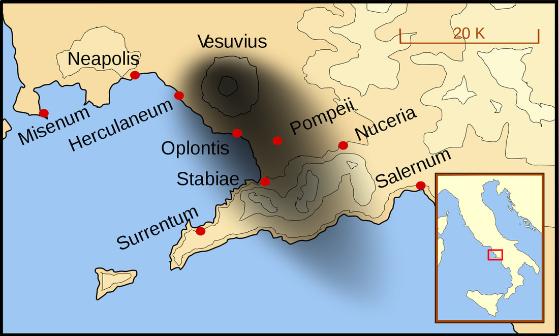
- the geographical setting and natural features of Campania
- the eruption of AD 79 and its impact on Pompeii and Herculaneum
- early discoveries and the changing nature of excavations in the 19th and 20th centuries
- representations of Pompeii and Herculaneum over time
There is a tendency to examine Pompeii and Herculaneum as though they were cities not destroyed but preserved perfectly from 2000 years ago. Much of the research and popularisation of these towns has stemmed from the year of the eruption and centred on the lives and deaths of the inhabitants. However, it is important to note that Pompeii and Herculaneum existed long before the year 79 CE, and their earlier histories contribute much to the historical records. Before 79, they were common Roman towns, the eruption of Vesuvius making them unique. What is most interesting about these towns to the historian is not what makes them unique but what makes them common. This is how historians and archaeologists can glimpse what life must have been like for a bustling commercial Roman town in the 1st century.
the geographical setting and natural features of Campania
Pompeii
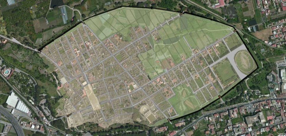
- The town of Pompeii covered an area of 66 ha (22 uncovered still) and surrounded by defensive walls.
- The grid pattern, developed in other Roman towns, was not precisely applied to Pompeii.
- The blocks/ insulae varied in size from 850 – 5500 m and some contained only one house while others contained a dozen or more.
- Herculaneum followed the classical layout of Greek towns with narrow straight streets that divide the town into insulae.
Activities
As you read through the following, annotate a map to show where these features are located.
Features
Walls
Walls
- Walls surround and enclose the city with a perimeter of 3.2 kms. Seven gates open in the walls and many speculate the existence of an eighth “Porta Capua”.
- Herculaneum had a sea wall, with large vaulted chambers for boats.
- The last intervention on the walls was undertaken around the period of the Social Wars (late 2nd
- City gates were positioned at the end of the main thoroughfares
- The most impressive examples of Gates at Pompeii are the Marine Gate and the Herculaneum Gate
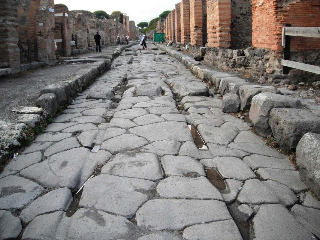
Streets
- Streets in Pompeii are extremely varied, some built with solid Roman engineering and underlain with water conduits; some dirt paths; some wide enough for two carts to pass; some alleys barely wide enough for pedestrian traffic.
- There are many different names for the dissimilar types of streets in both Herculaneum and Pompeii. The main highway that leads from Pompeii’s main gate is call the Via dell’Abbandanza.
- The Via dell’Abbandanza is one of the main Decumani running the length of the town, east to west.
- The Cardines run north to south, both meet at right angles.
- The Pompeian road network is- in itself- a reflection of the nascent origins and development of the city.
- Emanating from the forum, the streets of early Pompeii are not geometrically aligned , however later Pompeian districts have a more organised infrastructural road system containing main axial highways “decumani” which are perpendicularly crossed by minor streets known as “cardini” giving rise to isolated blocks “insulae”- such are occupied by more than one house, or in some circumstances a single house or public building.
- Another observation that can be made from Pompeian roads is the logically placed holes on the edge of pavements, thought to hold posts which support street stalls or sunblinds, and in some instances are hypothesized to transport animals.
- In order to facilitate pedestrian crossing and to protect their feet from rainwater and sewage which flow through the carriageway, there are ovoid shaped stepping stones placed between two pavements which were made from the same materials as the road surface, and were generally needed in areas close to entrances of buildings.
Drainage
- With the exception of the forum- Pompeii has no drainage network, causing the dirty runoff and sewage to run into the streets. However, the streets are built on an incline and the water flows out of the city towards open outlets at the foot of the city walls.
- There are large slabs of larva on the streets allowing pedestrians to cross the road in a civilised manner and not step in sewage or run off from rain.
- Herculaneum has a more advanced and adequate sewage system.
- Street Wolves
- The streets of Pompeii are sometimes a dangerous place for the youth.
- Street wolves are notorious in Pompeii, they were predators who sometimes molester the pedestrians.
- The youth to wear a purple stripe on their robes to identify those too young for incarceration.
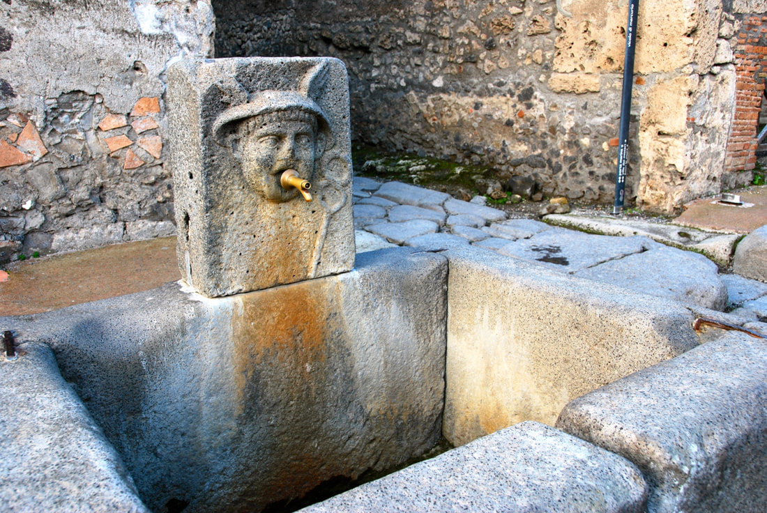
- Fountains
- The public water fountains- nymphea- flow day and night for the consumption of the public
- Public water fountains are conveniently located at many street corners – meeting the needs of the population.
- There are 42 fountains in Pompeii and they vary little in form.
- Water is transported by a lead pipe and gushes out of a decorative spout.
- The town’s water supply is brought from the springs of the Acquaro River by the Serinum aqueduct and the water is then distributed from the castellum aquae (water tower) situated at the highest point in the town near the Vesuvian Gate.
archaeologist: Sumiyo Tsujimura
In 1991 Sumiyo Tsujimura published, "Ruts in pompeii - the traffic system in the Roman city". Tsujimura led a Japanese team of archeologists to examine the wheel ruts, stepping-stones and other street features to establish how much traffic passed through Pompeii. By mapping these features Tsujimura has established:
- Traffic in Pompeii was controlled
- Some streets had no traffic
- The forum was elevated so as to stop all traffic
- The western end of the via dell’ Abbondanza served as a processional and pedestrian area free of traffic
